Embracing the future of geomodelling
In a groundbreaking collaboration, EMerald, SkyTEM, SDU, and NGI have joined forces to propel the future of geomodelling through the innovative AGAVE Project. This visionary initiative, acronymized as “AI-based Geo-models from UAV Geoscanning for sustainable infrastructure development” (AGAVE), marks a significant leap forward in the realm of geospatial exploration and sustainable infrastructure planning. For the first time in Europe, this pioneering project realized a historic turning point by securing permission for a sizable drone, equipped with an external load, to operate beyond controlled airspace. The synergy between EMerald’s technological prowess, SkyTEM’s expertise in airborne geophysics, SDU’s academic merit, and NGI’s leadership in geotechnical research has yielded unprecedented results.
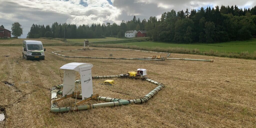
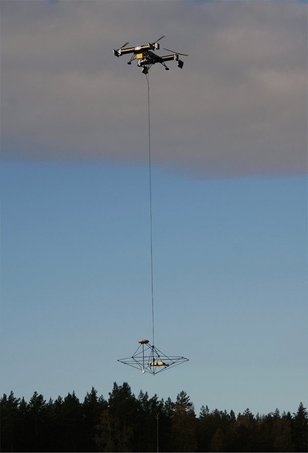
AGAVE’s objectives included the reduction of equipment size and weight, enabling the application of measuring instruments by UAVs or drones. Through the integration of a high-resolution ground investigation workflow, featuring a geoscanning system carried by a UAV, machine-learning-based data integration, and a significantly scaled-back invasive sampling program, the project seeks to elevate sustainability in the construction sector. Harnessing drone based technology will enable flights at lower altitudes. This, in turn, enhances measurement accuracy and resolution. Specifically, it focuses on the initial meters of the subsurface.
Andi A. Pfaffhuber, CEO, EMerald Geomodelling:
“For more than ten years, we have repeatedly delivered and proven the value of airborne geoscanning in large-scale infrastructure projects worldwide. At the same time, we continuously face the challenge of not being able to serve the vast market of small- to medium-scale projects due to the comparably high helicopter costs. A future scenario with less costly drone-based solutions will open that market and enable us to increase efficiency in such projects and contribute to more sustainable infrastructure planning and construction. “
Project achievements
Jussi Hermansen, Senior Specialist, SDU:
“Achieving successful approval for the Specific Operations Risk Assessment (SORA) of such an intricate and heavy-duty platform and payload feels like a dream coming true. Just a few years ago it would have been considered impossible to get permission to operate such a system.”
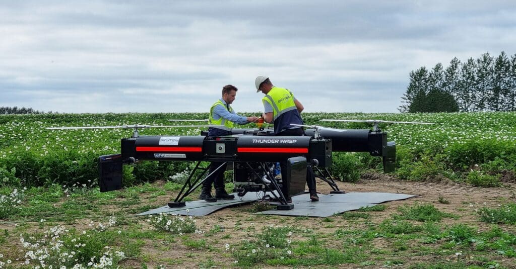
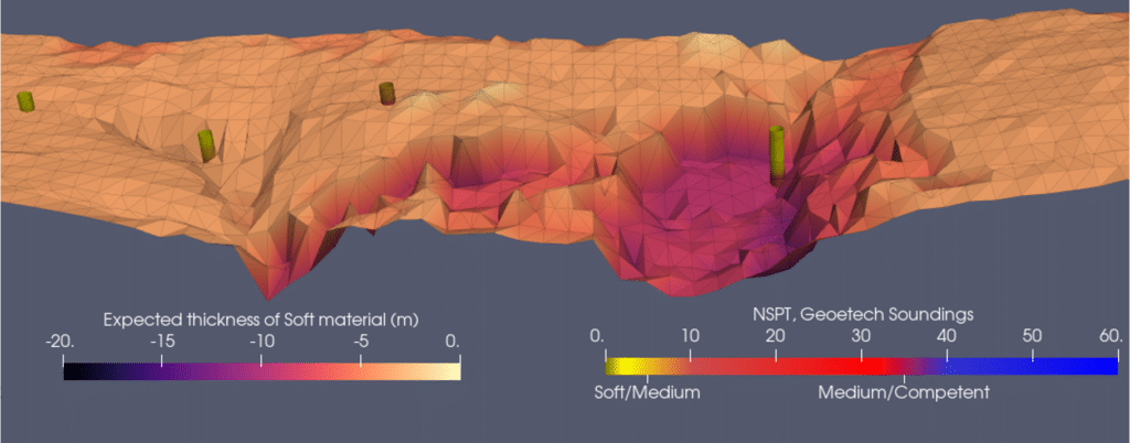
Throughout the AGAVE project, two pivotal achievements have significantly advanced the development of the drone based system. Firstly, obtaining approval for flying the drone system is a noteworthy milestone, representing, to the best of our knowledge, the first instance of its kind in Europe. Field tests in Denmark corroborated this accomplishment, led by project partners SkyTEM andSDU. The data acquired from the drone demonstrated superior resolution compared to data collected from the same location using ground-based geophysical methods. System tests conducted in Norway and Denmark displayed the capacity to present real world data with the current version of the instrument. This outcome, validated and deemed a notable achievement within the project, was particularly highlighted during geotechnical assessments carried out by project partner NGI in Norway. Notably, a representative smaller system was tested using a helicopter, displaying the versatility and applicability of the new generation results.
Another pivotal achievement is that EMerald is now ready to manage drone-generated data as the technology transitions to commercialization. Adopting this technology will amplify the efficiency and value of data collection through enhancements to the back-end infrastructure. Initial prototypes of workflows and algorithms were operational at the onset of the project, forming the basis for initial interpretation products. EMerald achieved notable progress during the project, focusing on exploring novel approaches, architectural structures, and infrastructure improvements. This effort led to the development of new products and interpretations. As a result, the emerging technology stands out as a more robust and efficient alternative. The technology is presenting enhanced value for EMerald’s future customers.
Magnus Rømoen, BIM strategist, NGI:
“Pilot tests with the prototype systems have confirmed what we had hoped for: The smaller system, the lower flight altitude and new machine learning workflows provide better resolution and accuracy than we previously got. This is a cornerstone for real-life application of drone-based systems in geotechnical works.”
The road ahead
The system has already received approval in Denmark. The next phase after AGAVE involves transferring the approval to Norway over the next year, in collaboration with project developers and contractors. Once fully developed, EMerald aspires to elevate the system to become the new standard for geotechnical investigations, thereby reducing service costs and increasing the sustainability of infrastructure investments.
Kristoffer Skovgaard Mohr, Head of R&D and Manufacturing, SkyTEM Surveys:
“Drone-based survey systems are a turning point in our industry and remind us of the paradigm shift caused by the introduction of helicopter-based TEM, which disrupted the fixed-wing TEM market. It makes surveys more financially accessible for smaller-scale projects and demonstrates our dedication to our mission of promoting sustainable surveying.”
The solution will also open doors to new markets in the future. The current helicopter based solution carries a substantial entry cost while offering comparatively lower resolution. It is limiting the return on investment for smaller infrastructure projects reliant on precision and constrained ground investigation budgets. On the other hand, the UAV-based workflow emerges as a viable solution. It promises lower costs, faster deployment and superior accuracy and resolution. The AGAVE project symbolizes a milestone for all the partners involved. The collaboration has set the stage for exciting developments in the future.
Andi A. Pfaffhuber, CEO, EMerald Geomodelling:
“The key element of the combined value chain starting with SkyTEM’s high-definition geophysical data and ending with EMerald’s ML–crafted 3D models is to provide subsurface information simply and rapidly. Scaling this value proposition in the coming years powered by a transition from helicopters to UAVs has the potential to disrupt.”
The AGAVE project supported by the Eurostar program
The Eurostar program is a joint program between EUREKA and the European Commission. It is designed to support innovative projects led by research and development performing small and medium-sized enterprises. Supported by funding from the European Union through Horizon 2020, this program empowers small enterprises to accomplish remarkable things.
The AGAVE project, led by Emerald Geomodelling, SkyTEM, SDU, and NGI, received Eurostar funding. It addresses the need for broader geological understanding, promoting sustainable solutions for the earth beneath our feet.